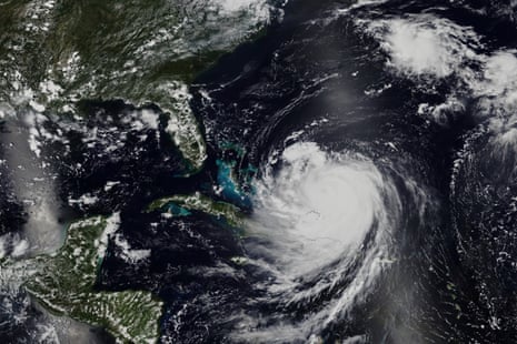
A formidable and intense storm, designated as Hurricane Erin, made its way toward the picturesque coastline of North Carolina, inciting a wave of urgent and widespread warnings as well as preparations throughout the state. The National Weather Service elevated Erin’s classification to a Category 3 storm, characterized by sustained winds that can reach an astonishing 125 miles per hour (201.17 kilometers per hour). Meteorologists forecasted that landfall was anticipated along the southeastern coast in the early hours of August 11th, creating a sense of urgency among residents and officials alike. As per the most recent advisories, Hurricane Erin advanced northeast at a speed of approximately 15 miles per hour (24.14 kilometers per hour), with the eye projected to make landfall near Wilmington. Coastal communities stretched from Cape Fear to the Outer Banks prepared for the impending onslaught of heavy rainfall, with storm surges that exceeded 10 feet (ca. 3 m), and fierce winds capable of inflicting widespread devastation and destruction. Meteorologists sounded alarms regarding Erin’s slow-moving trajectory, which resulted in extended periods of rainfall, thereby heightening the risk of flooding in vulnerable low-lying areas. Emergency management officials fervently urged residents to remain vigilant and to comply with evacuation orders wherever they have been issued. As the storm continued its path, it is currently impacting southeastern cities and generating a multitude of challenges and complications for several states, including Massachusetts, New Jersey, and North Carolina. The situation remains fluid, and residents are advised to stay informed and prepared for any developments that may arise as Hurricane Erin approaches.


